
ܠܦܦܐ:Greater Middle East (orthographic projection).svg

Size of this PNG preview of this SVG file: 551 × 550 ܦܩܣܠ. Other resolutions: 240 × 240 ܦܩܣܠ | 481 × 480 ܦܩܣܠ | 769 × 768 ܦܩܣܠ | 1,026 × 1,024 ܦܩܣܠ | 2,052 × 2,048 ܦܩܣܠ.
ܠܦܦܐ ܫܪܫܝܐ (SVG file, nominally 551 × 550 pixels, file size: 684 KB)
Tarihi ortadoğu projesi
ܦܣܝܩܬ̈ܐ
| Description |
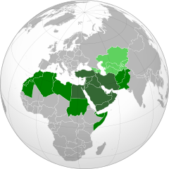
English: Map of the Greater Middle East, based on Perthes, V., 2004, America's "Greater Middle East" and Europe: Key Issues for Dialogue Archived 15 November 2008 at the Wayback Machine, Middle East Policy, Volume XI, No.3, Pages 85–97.
Traditional definition of the Middle East Greater Middle East (according to 2004 U.S. Government paper) Areas pundits sometimes associated with the Middle East around 2004 |
||||
| ܣܝܩܘܡܐ | |||||
| ܡܒܘܥܐ |
Own work (Original text: Own work,)
|
||||
| ܣܝܘܡܐ | Heraldry | ||||
| Permission (Reusing this file) |
|
||||
| Other versions |
.svg) |
||||
| SVG genesis |

.svg)
.svg)
.svg)
.svg)
.svg)
.svg)
.svg)
.svg)
.svg)
.svg)
.svg)
.svg)
.svg)
.svg)
.svg)
.svg)
.svg)
.svg)
.svg)
.svg)
.svg)
.svg)
.svg)
.svg)
.svg)
.svg)
.svg)
.svg)
.svg)
.svg)
.svg)
.svg)
.svg)
.svg)
.svg)
.svg)
.svg)
.svg)
.svg)
.svg)
.svg)
.svg)
.svg)
.svg)
.svg)
.svg)
.svg)
.svg)
.svg)
.svg)
.svg)
.svg)
.svg)
.svg)
.svg)
.svg)
.svg)
.svg)
.svg)
.svg)
.svg)
.svg)
.svg)
.svg)
.svg)
.svg)
.svg)
.svg)
.svg)
.svg)
.svg)
.svg)
.svg)

.svg)

.svg)

.svg)
.svg)
.svg)
.svg)
.svg)
.svg)
.svg)


.svg)
.svg)
.svg)
.svg)
.svg)
.svg)
.svg)

.svg)
.svg)
.svg)
.svg)
.svg)
.svg)
.svg)
.svg)
.svg)
.svg)

.svg)
.svg)
.svg)
.svg)
.svg)
.svg)
.svg)
_without_national_boundaries.svg)
.svg)
.svg)
.svg)
.svg)
.svg)
.svg)

.svg)
.svg)
.png)
.svg)
.svg)
.svg)
.svg)

.svg)
.svg)
.svg)
.svg)
.svg)
.svg)
.svg)
.svg)
.svg)
.svg)
.svg)

.svg)
.svg)
.svg)
.svg)
.svg)
.svg)
.svg)
.svg)
.svg)

.svg)
.svg)

.svg)
.svg)
.svg)
.svg)
.svg)
.svg)
.svg)
.svg)
.svg)
.svg)
.svg)
.svg)
.svg)
.svg)
.svg)
.svg)
.svg)
.svg)
.svg)
.svg)
.svg)
.svg)
.svg)
.svg)
.svg)
.svg)
.svg)
_-_Crimea_disputed.svg)
.svg)
.svg)
.svg)
.svg)
.svg)
.svg)
.svg)
.svg)
.svg)
.svg)
.svg)
_political.svg)
.svg)
.svg)
.svg)
.svg)
_-_Crimea_disputed_-_no_borders.svg)
.svg)
.svg)
.svg)
.svg)
.svg)
.svg)
.svg)
.svg)
.svg)
.svg)
.svg)

.svg)
.svg)
.svg)

.png)
.svg)
.svg)
.svg)
.svg)
.svg)
.svg)
.svg)
.svg)
.svg)
.svg)
.svg)
.svg)
.svg)
.svg)
.svg)
.svg)
.svg)
.svg)
.svg)
.svg)
.svg)
.svg)
.svg)
.svg)
.svg)
.svg)
.svg)
.svg)
.svg)
.svg)
.svg)
.svg)
.svg)
.svg)
.png)
.svg)
.svg)
.svg)
_(orthographic_projection).png)
.svg)
.svg)
.svg)
.svg)
.svg)
ܦܣܣܐ
I, the copyright holder of this work, hereby publish it under the following license:

|
Permission is granted to copy, distribute and/or modify this document under the terms of the GNU Free Documentation License, Version 1.2 or any later version published by the Free Software Foundation; with no Invariant Sections, no Front-Cover Texts, and no Back-Cover Texts. A copy of the license is included in the section entitled GNU Free Documentation License. |
| This file is licensed under the Creative Commons Attribution-Share Alike 3.0 Unported license. | ||
| ||
| This licensing tag was added to this file as part of the GFDL licensing update. |
ܬܫܥܝܬܐ ܕܠܦܦܐ
Click on a date/time to view the file as it appeared at that time.
.svg&dir=prev)
.svg&offset=20200224184514)
.svg&offset=&limit=20)
.svg&offset=&limit=50)
.svg&offset=&limit=100)
.svg&offset=&limit=250)
.svg&offset=&limit=500)
| ܣܝܩܘܡܐ/ܙܒܢܐ | ܨܘܪܬܐ ܙܥܘܪܬܐ | ܩܝܡ̈ܐ | ܡܦܠܚܢܐ | ܥܘܩܒܐ | |
|---|---|---|---|---|---|
| ܗܫܝܐ | 22:53, 25 ܒܚܙܝܪܢ 2024 | | 551 × 550 (684 KB) | M.Bitton | Reverted to version as of 23:16, 18 March 2023 (UTC): per COM:OVERWRITE. Please don't the borders again |
| 08:17, 22 ܒܐܝܪ 2024 |  | 550 × 550 (1.51 MB) | Abo Yemen | Reverted to version as of 17:26, 8 September 2023 (UTC):nationalistic vandalism | |
| 11:43, 1 ܒܐܝܪ 2024 |  | 551 × 550 (684 KB) | Anwar8989 | Reverted to version as of 23:16, 18 March 2023 (UTC) | |
| 17:26, 8 ܒܐܝܠܘܠ 2023 |  | 550 × 550 (1.51 MB) | Iktsokh | Got Malta back, fixed Tunisia's borders. | |
| 23:16, 18 ܒܐܕܪ 2023 |  | 551 × 550 (684 KB) | M.Bitton | Reverted to version as of 01:16, 10 June 2011 (UTC): per COM:OVERWRITE | |
| 21:53, 19 ܒܬܫܪܝܢ ܩܕܡ 2022 |  | 550 × 550 (1.53 MB) | Рагин1987 | Correction | |
| 12:06, 7 ܒܐܝܠܘܠ 2022 |  | 550 × 550 (1.51 MB) | Рагин1987 | Correction | |
| 05:46, 7 ܒܐܝܠܘܠ 2022 |  | 550 × 550 (1.52 MB) | Рагин1987 | Small correction | |
| 18:46, 24 ܒܫܒܛ 2020 |  | 550 × 550 (1.51 MB) | BasilLeaf | Reverted to version as of 19:50, 1 December 2015 (UTC) | |
| 18:45, 24 ܒܫܒܛ 2020 |  | 550 × 550 (1.51 MB) | BasilLeaf | update |
ܡܦܠܚܬܐ ܕܠܦܦܐ
ܠܝܬ ܦܐܬܐ ܕܐܣܪ ܠܗܢܐ ܠܦܦܐ.
ܡܦܠܚܢܘܬܐ ܓܘܢܝܬܐ ܕܠܦܦܐ
The following other wikis use this file:
- Usage on ar.wikipedia.org
- Usage on az.wikipedia.org
- Usage on be-tarask.wikipedia.org
- Usage on bg.wikipedia.org
- Usage on bn.wikipedia.org
- Usage on br.wikipedia.org
- Usage on ckb.wikipedia.org
- Usage on cs.wikipedia.org
- Usage on el.wikipedia.org
- Usage on el.wikinews.org
- Usage on en.wikipedia.org
- Usage on en.wikiversity.org
- Usage on es.wikipedia.org
- Usage on es.wikivoyage.org
- Usage on eu.wikipedia.org
- Usage on fa.wikipedia.org
- Usage on fa.wikinews.org
- Usage on he.wikipedia.org
View more global usage of this file.
.svg)
.svg)