
ܠܦܦܐ:Hamburg Subdivisions.svg

Size of this PNG preview of this SVG file: 608 × 599 ܦܩܣܠ. Other resolutions: 243 × 240 ܦܩܣܠ | 487 × 480 ܦܩܣܠ | 779 × 768 ܦܩܣܠ | 1,039 × 1,024 ܦܩܣܠ | 2,077 × 2,048 ܦܩܣܠ | 1,713 × 1,689 ܦܩܣܠ.
ܠܦܦܐ ܫܪܫܝܐ (SVG file, nominally 1,713 × 1,689 pixels, file size: 1.11 MB)
ܦܣܝܩܬ̈ܐ
| Description |
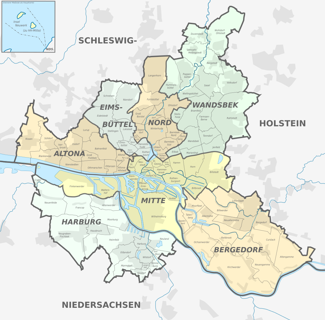
Deutsch: Karte der Verwaltungsgliederung Hamburgs.
English: Map of administrative divisions of Hamburg. |
| ܣܝܩܘܡܐ | |
| ܡܒܘܥܐ |
Own work
|
| ܣܝܘܡܐ |
TUBS |
| SVG genesis |
ܦܣܣܐ
I, the copyright holder of this work, hereby publish it under the following licenses:

|
Permission is granted to copy, distribute and/or modify this document under the terms of the GNU Free Documentation License, Version 1.2 or any later version published by the Free Software Foundation; with no Invariant Sections, no Front-Cover Texts, and no Back-Cover Texts. A copy of the license is included in the section entitled GNU Free Documentation License. |
This file is licensed under the Creative Commons Attribution-Share Alike 3.0 Unported license.
- You are free:
- to share – to copy, distribute and transmit the work
- to remix – to adapt the work
- Under the following conditions:
- attribution – You must give appropriate credit, provide a link to the license, and indicate if changes were made. You may do so in any reasonable manner, but not in any way that suggests the licensor endorses you or your use.
- share alike – If you remix, transform, or build upon the material, you must distribute your contributions under the same or compatible license as the original.
You may select the license of your choice.

|
I'd greatly appreciate, that you attribute this media file to Wikimedia Commons, if used outside Wikipedia or Commons. For use in publications such as books, newspapers, blogs, websites, please insert here the following line:
|
ܬܫܥܝܬܐ ܕܠܦܦܐ
Click on a date/time to view the file as it appeared at that time.
| ܣܝܩܘܡܐ/ܙܒܢܐ | ܨܘܪܬܐ ܙܥܘܪܬܐ | ܩܝܡ̈ܐ | ܡܦܠܚܢܐ | ܥܘܩܒܐ | |
|---|---|---|---|---|---|
| ܗܫܝܐ | 21:05, 1 ܒܟܢܘܢ ܐܚܪܝ 2013 | | 1,713 × 1,689 (1.11 MB) | TUBS | Steils -hoop |
| 21:26, 23 ܒܟܢܘܢ ܐܚܪܝ 2012 |  | 1,713 × 1,689 (2.14 MB) | TUBS | corr "Ottensen" & "Sasel" | |
| 08:30, 6 ܒܟܢܘܢ ܐܚܪܝ 2011 |  | 1,713 × 1,689 (2.14 MB) | TUBS | aktualisiert | |
| 09:02, 31 ܒܐܝܪ 2010 |  | 560 × 549 (1.93 MB) | TUBS | Marienthall is actually Marienthal | |
| 20:20, 26 ܒܐܝܪ 2010 |  | 560 × 549 (1.94 MB) | TUBS | {{Information |Description={{de|Karte der Verwaltungsgliederung Hamburgs.}} {{en|Map of administrative divisions of Hamburg.}} |Source={{own}}{{Adobe Illustrator}}{{Commonist}}</br>Based on: *[[:File:Hamburg location map.s |
ܡܦܠܚܬܐ ܕܠܦܦܐ
ܦܐܬܐ ܗܕܐ ܐܣܪ ܥܡ ܗܢܐ ܠܦܦܐ:
ܡܦܠܚܢܘܬܐ ܓܘܢܝܬܐ ܕܠܦܦܐ
The following other wikis use this file:
- Usage on an.wikipedia.org
- Usage on ca.wikipedia.org
- Usage on de.wikipedia.org
- Usage on en.wikipedia.org
- Usage on es.wikipedia.org
- Usage on ga.wikipedia.org
- Usage on hr.wikipedia.org
- Usage on lmo.wikipedia.org
- Usage on mk.wikipedia.org
- Usage on no.wikipedia.org
- Usage on pt.wikipedia.org
- Usage on rm.wikipedia.org
- Usage on sl.wikipedia.org
- Usage on sv.wikipedia.org
- Usage on vi.wikipedia.org
- Usage on zh-min-nan.wikipedia.org