
ܠܦܦܐ:Almazán (Soria) Mapa.svg

Size of this PNG preview of this SVG file: 500 × 400 ܦܩܣܠ. Other resolutions: 300 × 240 ܦܩܣܠ | 600 × 480 ܦܩܣܠ | 960 × 768 ܦܩܣܠ | 1,280 × 1,024 ܦܩܣܠ | 2,560 × 2,048 ܦܩܣܠ.
ܠܦܦܐ ܫܪܫܝܐ (SVG file, nominally 500 × 400 pixels, file size: 200 KB)
_Mapa.svg)
ܦܣܝܩܬ̈ܐ
| Description |
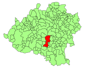
Español: Situación de Almazán en la provincia de Soria (España) |
| ܣܝܩܘܡܐ | 2 ܒܢܝܣܢ 2007 (upload date) |
| ܡܒܘܥܐ | Version de Image:Soria - Mapa municipal.svg de User:Tony Rotondas |
| ܣܝܘܡܐ | Nueva versión de User:HiTe |
| Permission (Reusing this file) |
GFDL |
| Other versions | Image:Soria - Mapa municipal.svg |
ܦܣܣܐ
| I, the copyright holder of this work, release this work into the public domain. This applies worldwide. In some countries this may not be legally possible; if so: I grant anyone the right to use this work for any purpose, without any conditions, unless such conditions are required by law. |
ܬܫܥܝܬܐ ܕܠܦܦܐ
Click on a date/time to view the file as it appeared at that time.
| ܣܝܩܘܡܐ/ܙܒܢܐ | ܨܘܪܬܐ ܙܥܘܪܬܐ | ܩܝܡ̈ܐ | ܡܦܠܚܢܐ | ܥܘܩܒܐ | |
|---|---|---|---|---|---|
| ܗܫܝܐ | 18:29, 2 ܒܢܝܣܢ 2007 | | 500 × 400 (200 KB) | HiTe~commonswiki | {{Information| |Description= {{es| Mapas de municipios de la provincia de Soria}} |Source= Version de Image:Soria - Mapa municipal.svg de User:Tony Rotondas |Date= 2-4-2007 |Author= Nueva versión de User:HiTe |Permission= GFDL |other_version |
ܡܦܠܚܬܐ ܕܠܦܦܐ
ܦܐܬܐ ܗܕܐ ܐܣܪ ܥܡ ܗܢܐ ܠܦܦܐ:
ܡܦܠܚܢܘܬܐ ܓܘܢܝܬܐ ܕܠܦܦܐ
The following other wikis use this file:
- Usage on ace.wikipedia.org
- Usage on ang.wikipedia.org
- Usage on ar.wikipedia.org
- Usage on arz.wikipedia.org
- Usage on ast.wikipedia.org
- Usage on ay.wikipedia.org
- Usage on azb.wikipedia.org
- Usage on ba.wikipedia.org
- Usage on bcl.wikipedia.org
- Usage on bi.wikipedia.org
- Usage on br.wikipedia.org
- Usage on ca.wikipedia.org
- Usage on cbk-zam.wikipedia.org
- Usage on ceb.wikipedia.org
- Usage on ch.wikipedia.org
- Usage on co.wikipedia.org
- Usage on csb.wikipedia.org
- Usage on da.wikipedia.org
- Usage on diq.wikipedia.org
- Usage on dv.wikipedia.org
- Usage on el.wikipedia.org
- Usage on eml.wikipedia.org
- Usage on en.wikipedia.org
- Usage on eo.wikipedia.org
- Usage on et.wikipedia.org
- Usage on eu.wikipedia.org
- Usage on fa.wikipedia.org
- Usage on ff.wikipedia.org
- Usage on fiu-vro.wikipedia.org
- Usage on fi.wikipedia.org
- Usage on frp.wikipedia.org
- Usage on fr.wikipedia.org
- Usage on fur.wikipedia.org
- Usage on gag.wikipedia.org
- Usage on gd.wikipedia.org
- Usage on gl.wikipedia.org
- Usage on hak.wikipedia.org
- Usage on haw.wikipedia.org
- Usage on hsb.wikipedia.org
- Usage on ht.wikipedia.org
- Usage on hu.wikipedia.org
- Usage on hy.wikipedia.org
- Usage on ia.wikipedia.org
- Usage on id.wikipedia.org
- Usage on ie.wikipedia.org
- Usage on incubator.wikimedia.org
View more global usage of this file.
_Mapa.svg)
_Mapa.svg)