
ܠܦܦܐ:Levant.gif
ܠܝܬ ܢܩܕܘܬܐ ܝܬܝܪ ܡܢ ܗܢܐ.
Levant.gif (322 × 241 ܦܩܣܠ، ܥܓܪܐ ܕܠܦܦܐ: 5 KB، ܐܕܫܐ ܕ MIME: image/gif)
ܦܣܝܩܬ̈ܐ
| Description |
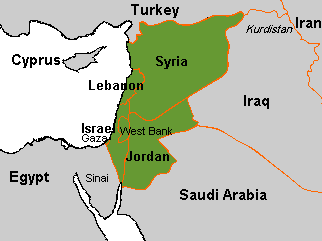
The modern Levant العربية: صورة للخريطة التي تمثل بلاد الشام الحديثة، حيث يمثل اللون الأخضر بلاد الشام (سوريا، الأردن، فلسطين، لبنان). |
| ܡܒܘܥܐ | http://en.wikipedia.org/wiki/Image:Levant.GIF |
| ܣܝܘܡܐ | User:Arab League |
| Permission (Reusing this file) |
public domain |
ܦܣܣܐ
| This work has been released into the public domain by its author, Arab League. This applies worldwide. In some countries this may not be legally possible; if so: |
ܬܫܥܝܬܐ ܕܠܦܦܐ
Click on a date/time to view the file as it appeared at that time.
| ܣܝܩܘܡܐ/ܙܒܢܐ | ܨܘܪܬܐ ܙܥܘܪܬܐ | ܩܝܡ̈ܐ | ܡܦܠܚܢܐ | ܥܘܩܒܐ | |
|---|---|---|---|---|---|
| ܗܫܝܐ | 02:02, 3 ܒܬܡܘܙ 2010 | | 322 × 241 (5 KB) | Dcoetzee | Remove watermark (coastline may not be quite right) |
| 15:50, 12 ܒܟܢܘܢ ܐܚܪܝ 2008 |  | 322 × 241 (5 KB) | Gusgus | {{Information |Description= |Source=http://en.wikipedia.org/wiki/Image:Levant.GIF |Date= |Author=Arab League (Talk | contribs) |Permission= public domain |other_versions= }} Category:Maps of the Levant |
ܡܦܠܚܬܐ ܕܠܦܦܐ
ܦܐܬܐ ܗܕܐ ܐܣܪ ܥܡ ܗܢܐ ܠܦܦܐ:
ܡܦܠܚܢܘܬܐ ܓܘܢܝܬܐ ܕܠܦܦܐ
The following other wikis use this file:
- Usage on ar.wikipedia.org
- تاريخ سوريا
- تاريخ لبنان
- سوريا الكبرى
- مارك سايكس
- قالب:تاريخ بلاد الشام
- قالب:رأس وإيقونة
- تاريخ الأردن
- تاريخ بلاد الشام
- بوابة:الشام
- بوابة:الشام/قوالب
- الإسلام في الشام
- تاريخ لبنان القديم
- الأشوريين في لبنان
- البابليون في لبنان
- الفراعنة في لبنان
- آثار نهر الكلب
- الأبرشية المشرقية
- قالب:رأس وإيقونة/شرح
- قالب:إطار 12
- قالب:إطار 12/شرح
- العرب في لبنان
- ويكيبيديا:مسابقة صور شامية/Rotana Nawwaf Al Hasanat
- المؤتمر الوطني الأردني الأول
- آل طرباي
- العصر الحجري الحديث في الشرق الأدنى
- Usage on de.wikipedia.org
- Usage on diq.wikipedia.org
- Usage on en.wikipedia.org
- Usage on fa.wikipedia.org
- Usage on fi.wikipedia.org
- Usage on frp.wikipedia.org
- Usage on ja.wikipedia.org
- Usage on la.wikipedia.org
- Usage on nl.wikipedia.org
- Usage on pl.wikipedia.org
- Wikiprojekt:Tygodnie tematyczne/Tydzień Artykułu Lewantyńskiego/Morze czerwone linków
- Wikiprojekt:Tygodnie tematyczne/Tydzień Artykułu Lewantyńskiego
- Wikiprojekt:Tygodnie tematyczne/Tydzień Artykułu Lewantyńskiego/Zaproszenie
- Wikipedia:Tablica ogłoszeń/2015-05
- Wikiprojekt:Tygodnie tematyczne/Zestawienie zaproszeń
- Usage on pl.wiktionary.org
- Usage on ro.wikipedia.org
- Usage on ru.wikipedia.org
- Usage on zh.wikipedia.org