
ܠܦܦܐ:Bitlis districts.png

ܥܓܪܐ ܕܓܠܚܐ: 776 × 600 ܦܩܣܠ. Other resolutions: 311 × 240 ܦܩܣܠ | 621 × 480 ܦܩܣܠ | 994 × 768 ܦܩܣܠ | 1,056 × 816 ܦܩܣܠ.
ܠܦܦܐ ܫܪܫܝܐ (1,056 × 816 ܦܩܣܠ، ܥܓܪܐ ܕܠܦܦܐ: 24 KB، ܐܕܫܐ ܕ MIME: image/png)
ܦܣܝܩܬ̈ܐ
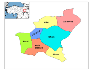
| Description | Map of the districts of Bitlis province in Turkey. Created by Rarelibra 18:56, 1 December 2006 (UTC) for public domain use, using MapInfo Professional v8.5 and various mapping resources. Edited by One Homo Sapiens Corrected text where İ,Ş,ı,ğ,or ş occurs in name. Source: [statoids-com]. Increased font size and enhanced color differences among adjacent districts. |
| ܣܝܩܘܡܐ | 1 ܒܟܢܘܢ ܩܕܡ 2006 (original upload date) |
| ܡܒܘܥܐ | No machine-readable source provided. Own work assumed (based on copyright claims). |
| ܣܝܘܡܐ | No machine-readable author provided. Rarelibra assumed (based on copyright claims). |
ܦܣܣܐ
| I, the copyright holder of this work, release this work into the public domain. This applies worldwide. In some countries this may not be legally possible; if so: I grant anyone the right to use this work for any purpose, without any conditions, unless such conditions are required by law. |
ܬܫܥܝܬܐ ܕܠܦܦܐ
Click on a date/time to view the file as it appeared at that time.
| ܣܝܩܘܡܐ/ܙܒܢܐ | ܨܘܪܬܐ ܙܥܘܪܬܐ | ܩܝܡ̈ܐ | ܡܦܠܚܢܐ | ܥܘܩܒܐ | |
|---|---|---|---|---|---|
| ܗܫܝܐ | 21:27, 28 ܒܟܢܘܢ ܩܕܡ 2008 | | 1,056 × 816 (24 KB) | One Homo Sapiens | Corrected text where İ,Ş,ı,ğ,or ş occurs in name. Source: [statoids-com]. Increased font size and enhanced color differences among adjacent districts. |
| 18:56, 1 ܒܟܢܘܢ ܩܕܡ 2006 |  | 1,056 × 816 (24 KB) | Rarelibra | Map of the districts of Bitlis province in Turkey. Created by ~~~~ for public domain use, using MapInfo Professional v8.5 and various mapping resources. |
ܡܦܠܚܬܐ ܕܠܦܦܐ
ܦܐܬܐ ܗܕܐ ܐܣܪ ܥܡ ܗܢܐ ܠܦܦܐ:
ܡܦܠܚܢܘܬܐ ܓܘܢܝܬܐ ܕܠܦܦܐ
The following other wikis use this file:
- Usage on ar.wikipedia.org
- Usage on arz.wikipedia.org
- Usage on ast.wikipedia.org
- Usage on azb.wikipedia.org
- Usage on az.wikipedia.org
- Usage on ca.wikipedia.org
- Usage on ceb.wikipedia.org
- Usage on cs.wikipedia.org
- Usage on de.wikipedia.org
- Usage on diq.wikipedia.org
- Usage on en.wikipedia.org
- Usage on eo.wikipedia.org
- Usage on es.wikipedia.org
- Usage on eu.wikipedia.org
- Usage on fa.wikipedia.org
- Usage on fi.wikipedia.org
- Usage on fr.wikipedia.org
- Usage on hu.wikipedia.org
- Usage on hy.wikipedia.org
- Usage on id.wikipedia.org
- Usage on it.wikipedia.org
- Usage on ja.wikipedia.org
- Usage on jv.wikipedia.org
- Usage on ka.wikipedia.org
View more global usage of this file.